
The MGLP is excited to announce the release of its all-new Conservation Planner 2.0. Building on years of database expansion, the planner shares information from over 100 datasets for lakes across the Upper Midwest. With information on gamefish, water quality, land use and land cover, non-native species, physical characteristics, social information, and more, the revised Conservation Planner 2.0 is a powerful tool to inform conservation on lakes near you.
The planner allows you to create custom queries using over 75 different variables to compare lakes in your area. If you want to learn more about a specific lake, the planner can create a customized 30-page report for each lake in the partnership, which synthesizes and explains available data in a format that can be easily shared with partners.
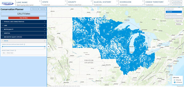
The Lake Viewer function in the Conservation Planner 2.0 enables comparisons across over 129,000 lakes.
As you know, smart conservation requires learning the specifics about the ecological system that one is protecting or restoring. Understanding the threats facing lakes, the trends in lakes’ conditions, and how they compare with similar nearby lakes can guide expectations and conservation strategies. The MGLP Conservation Planner 2.0 expands upon and complements existing tools using data from state, federal, and tribal resource agencies, academic researchers, private consultants, and volunteer monitors.
Lake Viewer
The Lake Viewer function of the planner provides a basis for comparing lakes and understanding trends across the landscape. You can select and compare lakes that share characteristics from a list of over 75 variables, such as state, county, lake size, maximum depth, shoreland development, watershed development, nutrient levels, thermal class, modeled changes in abundance of gamefish species due to climate change, non-native species presence, the presence of boat ramps, and more.
Lake Report
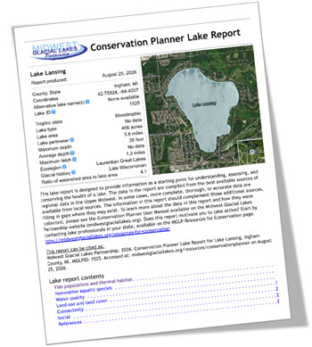
The Lake Report function is designed to provide information as a starting point for understanding, assessing, and conserving the health of an individual lake. Click on a lake and hit the “Generate lake report” button to see a customized 30-page document describing the lake, with a host of additional data such as time series of water quality data, maps of watershed land use and land cover, and more. You can save the report or export the maps within it to print or share with others.
Using the Conservation Planner
This resource is now available for all to use. Simply go to the MGLP’s Conservation Planner 2.0 webpage and start exploring! We’ll be hosting a webinar on Tuesday, September 22nd at 1 PM Central to provide an introduction and tutorial on the planner; sign up on our webinars page to learn more.
The Conservation Planner 2.0 is built upon a compilation of datasets. To learn more about the data supporting the planner or download Excel files to conduct your own analyses, check out the Data section of the Conservation Planner 2.0 webpage. More data such as shapefiles for watershed boundaries and maps of the water bodies used in the planner are available upon request.
Feedback
This Conservation Planner was a major effort to construct, and we’re excited to share it. We have been testing and updating the tool internally for months, but there are still improvements to be made! If you notice any issues with the tool, or if you have a suggestion for future datasets or functionalities that could be incorporated, please use the “Provide Feedback” button in the top right corner of the tool to share your suggestion.