
From time to time, we highlight research related to inland lake conservation that may be of interest to some partners.
Latest wakeboat research recommends 20-foot operating depth
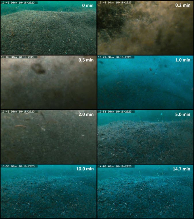
The University of Minnesota’s St. Anthony Falls Lab released their latest research report, “A Field Study of Recreational Powerboat Hydrodynamics and their Impacts on the Water Column and Lakebed”. Researchers assessed how wakeboats and typical motorboats created turbulence in the water column through propellor wash and other mechanisms. This turbulence can decrease water quality through sediment resuspension and can damage aquatic plants that provide important habitat for fish and other aquatic life. Videos (1, 2) from the study have been posted online, showing the effects of passing wakeboats at different depths. The study recommended that to minimize impact, recreational boats operating on plane should be in waters 10 feet or deeper, and wakeboats operating in wake-surfing mode should be in waters 20 feet or deeper. The study also recommended avoiding areas with aquatic vegetation to protect these habitats. The study’s authors will hold a webinar on August 26th to share the study’s findings and answer questions from the audience.
Remote-sensed water quality data available nationwide
Understanding water quality is critical to identifying changes in the health of a lake. The most basic measure of water quality is clarity, typically measured by how far down a black and white disk called a Secchi disk can be observed from the water’s surface. Secchi depths and other data have been collected by agency staff, private organizations, and volunteers thousands and thousands of times. However, there are still many lakes with incomplete data or no data at all. Even on lakes that only have Secchi depth measurements, we may not know whether the lack of clarity comes from suspended solids, chlorophyll-a-producing algae, dissolved organic compounds that “brown” the water, or other sources. Since many of these aspects of water clarity can be derived simply by “looking” down at the water, it is possible to estimate them using satellites. A recent study used data from the LANDSAT satellite to estimate water quality on lakes greater than about 10 acres across the United States. The study provides for download over 35 million high quality estimates of chlorophyll, Secchi depth, true color, dissolved organic carbon, total suspended solids, or turbidity on lakes from 1984 – 2020, dramatically improving our ability to understand how lakes have changed over time.